Home
Proposals and survey
Proposals and survey
Introduction
We want to improve everyday life across the city, tackle climate change, and improve health and wellbeing. To help achieve this ambition, we are investing in transport infrastructure making Leeds safer for people walking, wheeling* and cycling. This supports our Transport Strategy for Leeds to be “a city where you don’t need to own a car”, aiming to increase walking by 33% and cycling by 400% by 2030.
Our road safety investment aims to improve safety for all road users and will help support our Leeds Safe Roads Vision Zero 2040 Strategy - which aims to have zero deaths on Leeds roads by 2040.
By improving the design of our streets, people and communities will be put first, before vehicles. More space for people, and less for cars helps people feel safe travelling in greener, healthier ways.
*Wheeling incorporates many methods for getting around, including using wheelchairs, mobility scooters, walking aids and travelling with a pram or pushchair
The following pages show our plans to improve the A660, detailing existing issues, proposed improvements, and the benefits of making these changes.
Further details are shown in the subsequent pages that are split into sections:
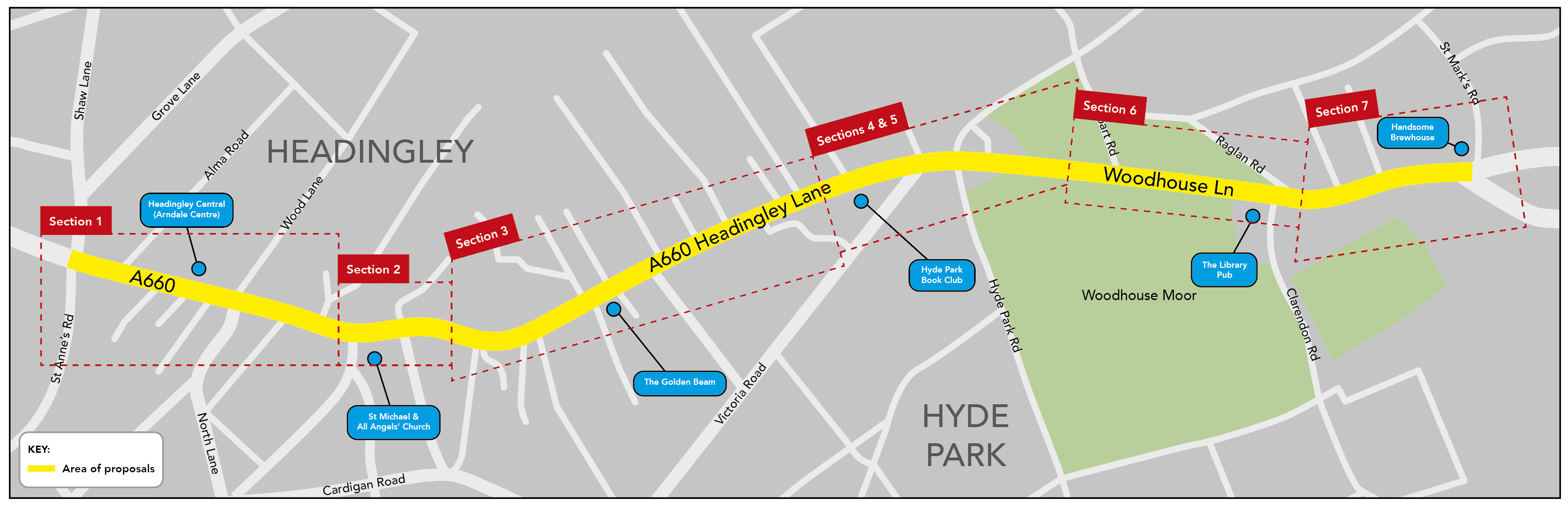
- Section 1: A660 Otley Road from Alma Road to Shire Oak Road
- Section 2: A660 Otley Road/Headingley Lane, St Michael’s Road junction
- Section 3: A660 Headingley Lane from Spring Road to Grosvenor Road
- Section 4: A660 Headingley Lane/Woodhouse Lane, Victoria Road junction
- Section 5: A660 Woodhouse Lane, Hyde Park Road junction (Hyde Park Corner) to Cliff Road
- Section 6: A660 Woodhouse Lane from Rampart Road to Clarendon Road
- Section 7: A660 Woodhouse Lane from St Mark’s Street to St Mark’s Road
- Section 8: Continuous crossings at side roads
- Section 9: Proposed segregated cycle path
Before you see the proposals and feedback, we would like to know how you use the area and the A660. Please answer the following questions before completing the survey.
Casualties along the route
A casualty is a person killed or injured in a collision

Between 2016-2021 there were 172 casualties along this section of the A660:
- 42% involved people cycling
- 29% involved people walking or wheeling*
- 29% involved people in motorised vehicles
Location of collisions along the route from January 2016 to December 2021 - a collision can involve multiple casualties:

Pedestrian fatality ocurred in 2018
*Wheeling incorporates many methods for getting around, including using wheelchairs, mobility scooters, walking aids and travelling with a pram or pushchair
Survey
The survey has several sections showing our proposals. If you wish to feedback on all of our sections you can do so by clicking next at the bottom of this page. Alternatively you can skip to a specific section or group of sections by using these links:
- Section 1: A660 Otley Road from Alma Road to Shire Oak Road
- Section 2: A660 Otley Road/Headingley Lane, St Michael’s Road junction
- Section 3: A660 Headingley Lane from Spring Road to Grosvenor Road
- Section 4: A660 Headingley Lane/Woodhouse Lane, Victoria Road junction
- Section 5: A660 Woodhouse Lane, Hyde Park Road junction (Hyde Park Corner) to Cliff Road
- Section 6: A660 Woodhouse Lane, Rampart Road to Clarendon Road
- Section 7: A660 Woodhouse Lane from St Mark’s Street to St Mark’s Road
- Section 8: Continuous crossings at side roads
- Section 9: Proposed segregated cycle path
Section 1: A660 Otley Road from Alma Road to Shire Oak Road

Grid A
Existing issues
- No dedicated space for people cycling
- Bus shelter restricts space for pedestrians
- Busy retail area with high footfall
- Hotspot for collisions
Proposals
- Re-configure and make better use of the space and paving outside the front of Headingley Central
- Provide a segregated cycle path between the road and a path for people walking and wheeling
- Replace bus shelter with a flag stop, and use sheltered walkway of Headingley Central as a place to wait for buses
- Real-time information screens for bus times, placed under sheltered walkway
- Narrow the carriageway and reduce speed limit from 30mph to 20mph between Shaw Lane/St Anne’s Road junction and St Michael’s Road
Benefits
- Safer for people walking, wheeling and cycling
- Fewer and less serious collisions
- Better layout and better use of space in front of Headingley Central
- People waiting for buses still have a shelter under the walkway of Headingley Central
Trade-offs
- Slightly longer journey times for motorised vehicles due to lowered speed limit
- Bus users will wait under sheltered walkway instead of a dedicated bus shelter

Headingley Central (Arndale Centre)

Grid B
Existing issues
- Busy junction with high footfall
- Hotspot for collisions – 13 collisions from January 2016 to December 2021
- People required to make two crossings at junction
Proposals
- North Lane junction to remain signalised but with the addition of a diagonal-crossing
- Responsive crossing times for people that need longer to cross
- Priority green signal release at junction for people cycling
- Metal guard rails and concrete bollards removed
Benefits
- A diagonal crossing allows people to cross in one movement instead of two
- Prioritises people over motorised vehicles
- People have adequate time to cross
- Safer for people cycling
- Removing guard rails and concrete bollards creates more space
Trade-offs
- Possibly longer waiting times at traffic signals for motorised vehicles

Example of diagonal crossing point
Section 2: A660 Otley Road/Headingley Lane, St Michael’s Road junction
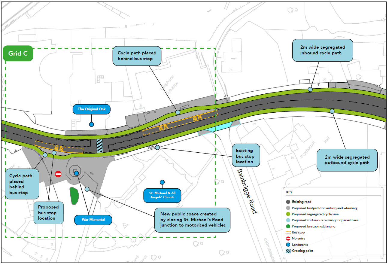

Artist's impression
Grid C
Existing issues
- Hotspot for collisions – 7 collisions from January 2016 to December 2021
- Vehicles rat-run along St. Michael’s Road
- Vehicles turning right out of St. Michael’s Road, onto A660 Otley Road, block outbound traffic
Proposals
- Close St Michael’s Road/A660 junction to motorised traffic preventing rat-running
- Create a space surrounding the War Memorial for benches, planting and possibly a rain garden
- Provide cycle parking
- Move existing bus stop from outside St. Michael and All Angels’ Church to the new pedestrianised area on St. Michael’s Road
- Upgraded, bus-responsive traffic signals
- Eight standard parking bays replaced with four blue badge parking bays and public space.
Benefits
- Safer for all road users and pedestrians
- Buses will have a GPS tracker giving them priority at traffic lights
- More space at new bus stop location
- Safer and improved community space with opportunity to host events, markets etc
- Parking prioritised for people that have access needs.
Trade-offs
- Possible longer journey times for rerouted motorised vehicles
- Removal of eight standard parking spaces
- St. Michael’s Road is no longer a through road for motorised vehicles

St Michael's Road/A660 junction
Alternative routes

Section 3: A660 Headingley Lane from Spring Road to Grosvenor Road


Existing issues
- Narrow footpath
- Existing Wands and Orcas* provide limited space and protection for people cycling
- Hotspot for casualties at side roads along this section of road
- Some outbound bus stops are infrequently used
Proposals
- New bus stop with real-time information screens placed outside The Golden Beam (J D Wetherspoon). This will replace infrequently used bus stops on A660 Headingley Lane at North Grange Road, North Hill Road and Richmond Avenue junctions
- Remove pedestrian guard rails, islands and hatchings from centre of the A660 Headingley Lane to create more space for improvements, including wider footpaths
Benefits
- More space for people walking, wheeling, and cycling
- Safer for people walking, wheeling, and cycling
- Relocated bus stop closer to more residents
- Relocated bus stop on a wider footpath and in a better lit area
- Faster bus journeys with fewer stops
Trade-offs
- Some residents may have longer to walk to the bus stop

*Example of wands and orcas currently in place on parts of A660.
Section 4: A660 Headingley Lane/Woodhouse Lane, Victoria Road junction


Artist's impression
Grid D
Existing issues
- Hotspot for collisions – 13 collisions from January 2016 to December 2021
- Motorised vehicles rat-run along Regent Park Avenue
- Inadequate provision and unsafe for people cycling
- Narrow and damaged footpaths
Proposals
- Close Regent Park Avenue junction to motorised traffic
- All arms of Victoria Road and A660 Headingley Lane junction signalised with crossings for people walking, wheeling, and cycling
- Create a dedicated lane for motorised vehicles turning left from A660 into Victoria Road
- People cycling outbound, across the arm of Victoria Road junction, to be given priority, whilst left-turning vehicles are held by signals to prevent collisions
- Create a public space and remove advertising billboards to create a more pleasant environment
- Ban the right turn into Victoria Road
- Remove overgrown shrubs
Benefits
- Enables signals to hold left-turning traffic into Victoria Road whilst keeping outbound traffic moving along the A660
- Improves safety for people walking, wheeling and cycling
- Improved community space, new planting and possibly a rain garden
- Reduces rat-running on Regent Park Avenue - a residential area
- Overgrown vegetation to be removed from space around advertising boards
- Damaged footpaths replaced and upgraded
Trade-offs
- Regent Park Avenue is no longer a through road for motorised vehicles
- Possibly longer waiting times at traffic signals

New public space created with planting and landscaping
Alternative routes

Section 5: A660 Woodhouse Lane, Hyde Park Road junction (Hyde Park Corner) to Cliff Road

Grid E
Existing issues
- Motorised vehicles are continuing to turn left from A660 Headingley Lane into Woodhouse Street despite this being a banned turn
- Hotspot for collisions – 18 collisions and one pedestrian fatality January 2016 to December 2021
- Inadequate provision and unsafe for people cycling
- Difficult for buses to re-join A660 Woodhouse Lane carriageway outbound after bus lane ends
- Difficult to cross the A660 Woodhouse Lane due to high volume of traffic, obstructive pedestrian guard rails and a lack of crossing facility
Proposals
- Build-out existing footway on corner of Woodhouse Street/A660, directly outside The Hyde Park pub, so it’s clearer to motorists this is an existing banned left turn
- Ban straight-ahead movement from Hyde Park Road to Woodhouse Street
- Cliff Road made one-way, with direction of travel from Woodhouse Street to Woodhouse Lane
- Ban right turn out of Cliff Road onto A660 Woodhouse Lane
- New signalised crossing between the bus shelter and Cliff Road
- Traffic signals placed on outbound bus lane of A660 Woodhouse Lane, giving buses priority
- Re-surface existing path (Avenue Walk) so people cycling can either use the bus lane or this path.
- Eleven trees removed to make space for improvements*
Benefits
- Safer for people walking, wheeling, and cycling
- Easier to cross the road
- Wider footpaths
- Improved public space
- Fewer motorised vehicles rat-running through residential streets
- Improved journey times along the A660 from fewer movements at traffic signals
- Buses will have a GPS tracker giving them priority at traffic lights
- Increase in tree planting in the area
Trade-offs
- Eleven trees removed
- Possible impact to grass verge
- Bus lane reduced to 3m
- Possible longer journey times for rerouted motorised vehicles
- Banned straight ahead movement from Hyde Park Road to Woodhouse Street for motorised vehicles
- Banned right turn out of Cliff Road onto A660 Woodhouse Lane
- Cliff Road becomes one way
*A qualified arborist has carried out a complete arboricultural tree survey of the 73 trees along this section of the A660. Where possible we have sought to avoid impacting any trees however, these plans would impact 11 semi-mature trees. Varieties impacted include Oak, Lime and Sycamore - two are rated good quality with the remaining nine rated low quality.
All these trees were found to have a mixture of issues, including squirrel damage, soil compaction, root disturbance, close proximity to a bus shelter, girdling roots, or in a general poor condition.
So that we can improve the design of our streets and make them wider and safer, we need to put people first. To achieve this along the A660, and particularly at this section of road where there is a high footfall of school students, we would need to remove these trees. Relocating the trees would not be possible due to the issues listed above. However, our policy is to replace every tree removed with a 3:1 semi-mature ratio.
 Hyde Park Road/A660 junction
Alternative routes

Section 6: A660 Woodhouse Lane, Rampart Road to Clarendon Road

Grid F
Existing issues
- Difficult to cross the A660 Woodhouse Lane due to high volume of traffic and lack of crossing facility
- Hotspot for collisions – 9 collisions from January 2016 to December 2021
- People cycling share space with buses
Proposals
- New signalised crossing on A660 Woodhouse Lane between Woodhouse Moor and Rampart Road
- Responsive crossing times for people that need longer to cross
- Ban right turn out of Rampart Road
- Resurface existing path (Avenue Walk). People cycling can either use the bus lane or this path
Benefits
- Safer for people walking, wheeling and cycling
- Easier to cross the road
- Alternative option for people cycling, away from road
- Improves connectivity for people walking and wheeling between Woodhouse Moor and Cinder Moor
Trade-offs
- Possible longer journey times for rerouted motorised vehicles
- People walking, wheeling and cycling share the path along Avenue Walk
Alternative routes

Grid G


Artist's impression
Existing issues
- Hotspot for collisions – 7 collisions from January 2016 to December 2021
- Difficult for buses to re-join A660 Woodhouse Lane carriageway inbound
- Difficult to cross the A660 Woodhouse Lane due to high volume of traffic and lack of crossing facility
- High footfall with students travelling to university campus
Proposals
- New signalised crossing on A660 Woodhouse Lane east of Clarendon Road junction
- Ban left turn out of Clarendon Road
- New signalised crossing for people cycling between Raglan Road and Clarendon Road
- Existing bus stop relocated to other side of the junction (west)
- Improved landscaping to replace concrete planters
- Responsive crossing times for people that need longer to cross
Benefits
- Safer for people walking, wheeling, and cycling
- More spacious bus stop and waiting facility by relocating bus stop
- Improved journey times for buses
- Improved planting and landscaping
- More pleasant environment
- Improves connectivity for people cycling between Clarendon Road and Raglan Road
Trade-offs
- Banned left turn out of Clarendon Road onto A660 Woodhouse Lane for motorised vehicles
- Possible longer journey times for rerouted motorised vehicles
Alternative routes

Section 7: A660 Woodhouse Lane from St Mark’s Street to St Mark’s Road

Grid H
Existing issues
- Hotspot for collisions – 9 collisions from January 2016 to December 2021
- High footfall with narrow footpaths
- Motorised vehicles rat-run along St Mark’s Street
- Lack of dedicated space for deliveries to local businesses
Proposals
- Make St Mark’s Street one-way from A660 Woodhouse Lane
- New loading bay on St Mark’s Street for local businesses
- Widen footpaths
Benefits
- Safer for people walking, wheeling, and cycling
- Dedicated loading bay for deliveries
- Reduces rat-running on St Mark’s Street
Trade-offs
- St Mark’s Street becomes one way
- Possible longer journey times for rerouted motorised vehicles

St Mark's Street junction

Grid I
Existing issues
- Congested bus stop, especially at peak times with students from Notre Dame College
- Narrow footpath doesn’t allow enough space for people waiting
- People walking and wheeling forced onto cycle path and carriageway
- Inadequate provision and unsafe for people cycling at Woodhouse Lane junction
Proposals
- Relocate bus stop closer towards traffic signals, by Handsome Brewhouse, where footpath is wider
- People cycling inbound, across the arm of St Mark’s Road junction, given priority, whilst left-turning vehicles are held by signals to prevent collisions
- Segregated cycle paths help people cycling turn right at the junction, towards the Parkinson Building
- Increase the size of pedestrian waiting islands
- All movements retained but existing three lanes become two lanes:
- left turn only
- straight ahead with right turn
Benefits
- Safer for people using the bus stop
- Safer for people walking, wheeling, and cycling
- More space for people waiting at bus stop
- Cyclists able to turn right safely towards Parkinson Building
Trade-offs
- Some people might have longer to walk to their nearest bus stop
- Possibly longer waiting times at traffic signals

Inadequate space for people using bus stop

St Mark's Road/A660 junction
Section 8: Continuous crossings at side roads
Continuous crossings extend the pavement across a side road, making crossing the road easier. They are designed to slow down vehicles when entering or exiting side roads and encourage vehicles to give way to people walking, wheeling and cycling.
Existing issues
- Despite recent changes to the Highway Code, motorised vehicles don’t always give way to pedestrians.
- 172 casualties including one pedestrian fatality between 2016-2021 along this section of the A660.
- Busy commercial centres and densely populated areas along the route with motorised vehicles prioritised over people walking, wheeling and cycling
Proposal
- Add continuous crossings to the following side roads along the A660:
- Alma Road
- Dennistead Crescent
- Chapel Street
- Shire Oak Street
- Bennett Road
- Shire Oak Road
- Bainbrigge Road
- Spring Road
- Springbank Crescent
- Richmond Avenue
- Oakfield
- Richmond Road
- The Poplars
- Orville Gardens
- Buckingham Road
- North Grange Road
- North Hill Road
- Ashwood Villas
- Cumberland Road
- Grosvenor Road
- St Mark’s Street
- St. Mark’s Avenue
Benefits
- Research shows motorised vehicles more likely to give way to people walking and wheeling when turning into a side road
- Slows motorised vehicles down
- Safer for all people walking and wheeling
- No need for dropped kerbs so making it easier for people wheeling (pushchairs and wheelchairs in particular)
- Fewer collisions

Example of continous crossing. Image credit: Camden Cyclists
Section 9: Proposed segregated cycle path
The A660 is a main road into and out of the city centre for motorised vehicles and people who walk, wheel or cycle, as well as a popular route for students living in the area accessing university and college campuses. It is one of the busiest cycle routes in Leeds with over 1,000 cyclists using it daily, however, it suffers from a high casualty rate with 172 casualties happening along this road during 2016-2021.
Existing issues
- No dedicated space for people cycling
- Unsafe for people cycling
Proposals
- Two-metre segregated cycle path inbound and outbound along most of the route
Benefits
- Connects with the Shaw Lane junction improvement scheme, currently in delivery
- Segregated space for people cycling
- Safer for people cycling
Trade-offs
- Narrower carriageway

Example of a segregated cycle path
This engagement phase has finished

...