Get project news
Do you want to receive an email when news items are posted?
Latest news
Stay involved in the discussion. Keep up to date with the latest news and share it with your fellow community members.
Have your say: help shape plans to improve walking, cycling and public transport along Woodhouse Lane
A new consultation has launched asking people for their views on travel-related issues between the centre of Leeds and the Hyde Park and Woodhouse areas.
We're asking people to identify current issues, what changes they'd like to see, and what they think should be prioritised to improve the Woodhouse Lane Gateway, which is a 2km section of route along Woodhouse Lane and Albion Street from St Mark’s Road to the Headrow in the city centre.
The scheme also covers the southern end of the A660, which links the city centre to Hyde Park and Headingley.
The Woodhouse Lane Gateway is already heavily used by people walking, cycling and using the bus. However, the area suffers from congestion which can delay bus journey times and it can be difficult to travel along the route by foot or by bike.
It also suffers from a high casualty rate with 98 reported casualties happening along roads within the Woodhouse Lane Gateway boundary since 2016, including 23 serious collisions.
If you live, work in, or travel along the route, you can have your say in the consultation before 19 February. Simply drop a pin on the map, let us know what changes you'd like to see and help prioritise improvements for a safer and more welcoming area.
Find out more and feed back in the consultation here.If you'd prefer, you can also attend a drop-in event at Leeds City Museum on 31 January (10am - 4pm).
Posted on 24th January 2024
by Connecting Leeds
Construction work begins on £10.4m A660 transport improvements
The ambitious plans along A660 Otley Road, Headingley Lane and Woodhouse Lane, have moved into delivery after the public consultation received a 62 per cent positive response.
The scheme aims to address a high number of casualties along the route whilst providing safer, alternative travel options for Leeds residents. Work includes safety improvements where the A660 meets key junctions; continuous crossings at side junctions, to give pedestrians and cyclists priority; widened pavements; additional benches to sit and rest; two-metre-wide segregated cycle paths, both inbound and outbound; improved bus stops and shelters, including relocating some stops; closing St Michael’s Road and Regent Park Avenue to motorised vehicles to prevent rat-running; six additional pedestrian crossings and improved landscaping along the route.
Construction of the £10.4million works, funded by Active Travel England, will be delivered in phases to reduce disruption, with work already underway between the junctions of Spring Bank Crescent and Richmond Road, near to The Golden Beam pub.
The cycle paths, in particular, are a welcome addition with 68 per cent of respondents backing the plans. The A660 is one of the busiest cycle routes in Leeds with over 1,000 cyclists using it daily. The cycle path will follow on from the recently completed Shaw Lane junction improvement scheme which includes a new-fully segregated cycle path.
The highways treatments are scheduled to complete in spring 2025. The schedule of work is:
Phase three: Ongoing, due to complete winter 2023.
A660 Headingley Lane from Spring Bank Crescent to Richmond Road
Phases four and six: Construction begins November 2023, due to complete summer 2024.
Phase 4: A660 Headingley Lane from Richmond Road to Victoria Road
Phase 6: A660 Woodhouse Lane from Hyde Park Corner to Cliff Road
Phase two: Construction begins early 2024, due to complete summer 2024.
Phase 2: A660 Otley Road from North Lane to Spring Bank Crescent
Phases seven, nine and 10: Construction begins early 2024, due to complete autumn/winter 2024.
Phase 7: A660 Woodhouse Lane from Cliff Road to Clarendon Road
Phase 9: A660 Woodhouse Lane from Clarendon Road to St Mark’s Road
Phase 10: A660 Woodhouse Lane/St Mark’s Road junction
Phases one and eight: Construction begins spring 2024, due to complete spring 2025.
Phase 1: A660 Otley Road from Shaw Lane to North Lane
Phase 8: A660 Woodhouse Lane/Clarendon Road junction
Phase five: Construction begins summer 2024, due to complete spring 2025.
A660 Headingley Lane/Hyde Park Corner/Victoria Road junction
For further information about each section, please visit the consultation materials.
Traffic management will be in operation whilst the works are carried out, and disruption will be kept to a minimum as possible, but there will inevitably be delays, and when temporary road closures are in operation, diversion routes will be well signed. To be kept up-to-date with any of the construction, our contractor Colas Ltd has an app, Hello Travaux, you can use. Download it by scanning the QR code below:
Posted on 17th October 2023
by Martin Walker
A660: Improving safety and the design of our streets - what you told us
Consultation findings
Thank you to everyone that fed back on our proposals for A660. The consultation ran from Monday 30th January to Sunday 5th March 2023 and received 1,709 responses. We have reviewed and analysed all the responses and have subsequently made some changes to the scheme. These are summarised at the bottom of this post.
Below are the main findings from feedback received from online surveys, paper surveys at events, postal surveys and emails received:
How do you feel about our proposals overall?:
Overall, 63% of respondents supported the proposals, 11% felt neutral and 25% of respondents felt negatively towards the scheme.
What is your connection to the area? (Multiple choice):

How do you travel along this route? (Multiple choice):

How would you like to travel along this route? (Multiple choice):

Section 1: A660 Otley Road from Alma Road to Shire Oak Road
Grid A:
The proposals in this section are:
The chart below shows the respondents overall sentiment to each of the proposals:

What will be better or worse?:

Overall, how do you feel about our proposals in Grid A?:

Grid B:
The proposals in this section are:
The chart below shows the respondents overall sentiment to each of the proposals:

What will be better or worse?:

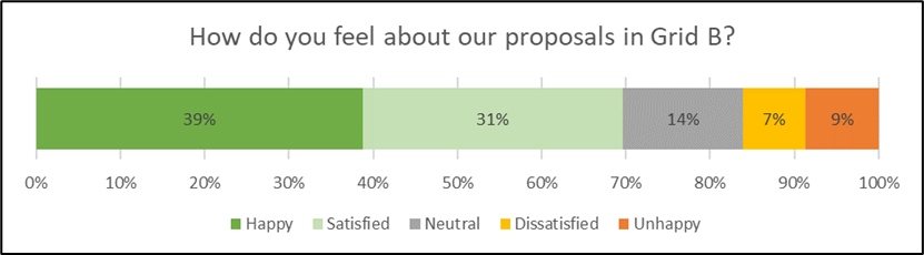
Overall, how do you feel about our proposals in Grid B?:
Section 2: A660 Otley Road/Headingley Lane, St Michael’s Road junction:
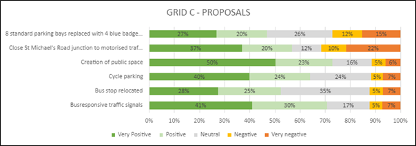
Grid C:
The proposals in this section are:
The chart below shows the respondents overall sentiment to each of the proposals:
What will be better or worse?:

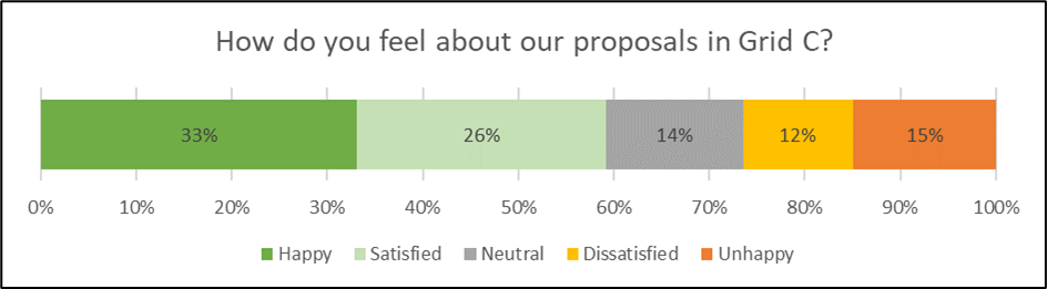
Overall, how do you feel about our proposals in Grid C?:
Section 3: A660 Headingley Lane from Spring Road to Grosvenor Road:
The proposals in this section are:
The chart below shows the respondents overall sentiment to each of the proposals:

What will be better or worse?:

Overall, how do you feel about our proposals in Section 3?:

Section 4: A660 Headingley Lane/Woodhouse Lane, Victoria Road junction:
Grid D:
The proposals in this section are:
The chart below shows the respondents overall sentiment to each of the proposals:

What will be better or worse?:

Overall, how do you feel about our proposals in Grid D?:

Section 5: A660 Woodhouse Lane, Hyde Park Road junction (Hyde Park Corner) to Cliff Road:
Grid E:
The proposals in this section are:
The chart below shows the respondents overall sentiment to each of the proposals:

What will be better or worse?:

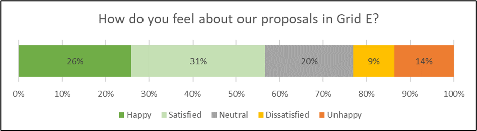
Overall, how do you feel about our proposals in Grid E?:
Section 6: A660 Woodhouse Lane, Rampart Road to Clarendon Road:
Grid F:
The chart below shows the respondents overall sentiment to each of the proposals:

What will be better or worse?:

Overall, how do you feel about our proposals in Grid F?:

Grid G:
The proposals in this section are:
The chart below shows the respondents overall sentiment to each of the proposals:

What will be better or worse?:

Overall, how do you feel about our proposals in Grid G?:

Section 7: A660 Woodhouse Lane from St Mark’s Street to St Mark’s Road:
Grid H:
The proposals in this section are:
The chart below shows the respondents overall sentiment to each of the proposals:

What will be better or worse?:

Overall, how do you feel about our proposals in Grid H?:

Grid I:
The proposals in this section are:
The chart below shows the respondents overall sentiment to each of the proposals:

What will be better or worse?:

Overall, how do you feel about our proposals in Grid I?:

Section 8: Continuous crossings at side roads:
This proposal is to add continuous crossings to the following side roads along the A660:
The chart below shows the respondents overall sentiment to the proposal:

What will be better or worse?:

Section 9: Proposed segregated cycle path:
The proposal in this section is to create a two-metre segregated cycle path inbound and outbound along most of the route. The chart below shows the respondents overall sentiment to the proposal:
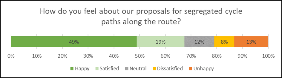
What will be better or worse?:

Changes to designs as a result of feedback from the consultation:
Section 1: Grid A
Section 2: Grid C
Section 5: Grid E
Section 7: Grid I
Special Thanks
Leeds City Council Highways and Transportation officers would like to extend their thanks to all those that have contributed to the consultation process. These responses are highly beneficial to support officers to shape and design transport projects.
Next Steps
We will keep residents and stakeholders informed about the progress of the scheme, via Commonplace and Connecting Leeds communication channels.
If you have any further queries, please contact connectingleeds@leeds.gov.uk.
Posted on 14th June 2023
by Connecting Leeds
A660 Consultation Update
Thank you for taking the time to complete our survey for the A660 consultation, which ran from the 30th January to 5th March 2023. We are now analysing all online, paper (both postal and from our drop-in events), and email responses received.
We will be in touch shortly to share the results from the consultation and inform you of the next steps.
Posted on 14th March 2023
by Connecting Leeds